| Vendee Information Vendee History Accommodation, Photos, Reviews, Maps, |
The River Lay
Sud
Vendee.. Haut
Bocage.. Coastal
Region.. Marais
Poitevin.. Marais
Breton.. Bas Bocage.. Plaine.. Marais
Olonne..
The River Lay is
the longest and largest of all the rivers in the Vendée, with its source at
Saint-Pierre-du-Chemin at a height of 195 meters above sea level . It flows
generally southwest for 120.3 kilomtres into the Bay of Biscay between La
Faute-sur-Mer and L'Aiguillon-sur-Mer. It is joined by the petit Lay just west of
Chantonnay and the River Smagne at Dissais before passing
through Mareuil-sur-lay and the wine producing region. It is then
joined by the river Yon before finally crossing the northern limits of the Marais
Poitevin.
Historically the River Lay has been very important both for the
draining of the marshlands of the Marais Poitevin and for commerce. Besides the
ports of l'Aiguillon and la Faute there were in Roman and medieval times,
smaller ports at Angle where the fortress of Moricq defended the river from
attacks and at St.Benoist and Curzon which
also had fortifications. The river and its tributaries also provided power by
way of the many watermills which were mainly for the grinding of
cereals.
Today the river's most important commercial functions are;
1.
The draining of the northern fringes of the Marais Poitevin though most of the
marshlands are connected to the vast network of canals which not only drain but
control the water levels of the whole area.
2. Irrigation. Above the
tidal reaches of the river water is taken for the irrigation of crops.
3.
Drinking water. There are several reservoirs both on the river Lay and its
tributaries the Yon and Marillet. They not only provide town water but are great
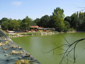
recreational areas. The Reservoirs are at La Rochereau just north of Chantonnay,
la Moulin Neuf, just south of Chantonnay, both on the River Lay. There are
further reservoirs on the River Yon at Moulin Papon on the outskirts of La
Roche-sur-Yon and finally on the river Marillet at Chateau
Guibert a few kilometers north of Mareuil-sur-Lay.
4. Fishing. The
sheltered mouth of the river provides a natural harbour for the commercial
fishing boats. From both L'Aiguillon-sur-Mer and La Faute-sur-Mer. The fishing
boats land their catches of locally caught fish for these are not ports for deep
sea fishing, it is also where sea anglers can catch a boat and take a days
fishing offshore.
The main commercial fishing however is in the cultivation
and harvesting of Mussels and to a lesser extent Oysters. It is claimed that one
third of all the Mussels harvested in France comes from the Anse de l'Aiguillon
with the port of L'Aiguillon taking the lions share.
Apart from the
commercial importance the River Lay acts as a long and beautiful recreational
playground offering a variety of activities to many people. From walks and
picnic areas, inspiration to painters and photographers, fishing on lake, the
river and its tidal waters and water sports such as canoeing and sailing. In
every aspect this is a very important asset to the Vendée.
The River
Yon. The largest of the tributaries that feed the River Lay rises a
few kilometres east of la Ferriere. It then travels north around the village
before heading south through Dompierre-sur-Yon before forming the reservoir of
Moulin Papon north of La Roche-sur-Yon. Meanders its way through La
Roche-sur-Yon the river forms a green corridor of walks and parks, which are
oases of peace and tranquiity. The Yon then flows south passing such attractions
as the Moulin de Rambourg and the Maison des Libellules at Chaille-sous-les Ormeaux before it
starts its decent through the steep sided valley below La Tablier
where large rounded boulders are strewn as if a giant had been playing marbles.
There are also the ruins of watermills which are also a reminder that the river
produced the power to drive industry here in centuries past. Standing above the
old mills is the Guinguette de Piquet a restaurant where musical festivals
take place during the summer months. From here the river skirts the Village of
Rosnay famed
as the centre of the Vendée's most productive wine growing region before joining the River
Lay.
Le Petit Lay. Had it not been for intervention by
politicians from Fontenay-le-Comte the Department would have been called the
Deux Lays and not the Vendée when it was created during the Revolution.
The Petit lay
rises to the north east of Les
Herbiers, close to the Puy du Fou,
it then flows south west as it collects the drainage waters of the Haut
Bocacge via its many tributaries. It passes below the hilltop village of Mouchamps
and enters the Bas Bocage on its way through St.Cecile as it meanders around
St.Hilaire-le-Vouhis before joining Le Grand Lay south of the Moulin Neuf
Reservoir at a point called L'Assemblee des Deux Lay.
La
Smagne. This Tributary rises near Bourseguin north of Fontenay le Comte
and flows west by way of St.Cyr-des Gats to Thire were it is incorporated
into the magnificent gardens of William Cristy at Le
Batiment. At St.Hermine it formed part of the defences of the Château du St.Hermine,
before meandering around the northern edge of the Plaine and
being incorporated into the gardens at the Loges
du Chaligny. It then bypassing the Chateau du
Bessay before joining the river Lay at Diss near Mareuil-sur-Lay.
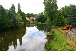
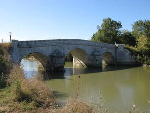
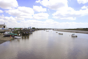
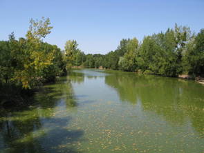
Photos of
the River Lay and its tributaries.
Return to find more Rivers of the
Vendée
In
accordance with the law "and Freedoms" of January 6, 1978, you have the right to
access and rectify information concerning you. If you wish to exercise this
right, please contact
us.
© Copyright Vendee-Guide.co.uk 2009-11
© Copyright Vendee-Guide.co.uk 2009-11
Loading