
Tourist Information, Vendee History, Accommodation, Photos, Reviews, Maps,

Custom Search
Web |

|
| contact us | ||
| Advertise |
|
| month by month guide | ||
| Entertainment |
| January | ||
| February | ||
| March | ||
| April | ||
| May | ||
| June | ||
| July | ||
| August | ||
| September | ||
| October | ||
| November | ||
| December |
| Car Boot Sale | ||
| Discos |
|
| Getting About | ||
| Public Holidays, | ||
| Getting to the Vendee | ||
| Bike Hire | ||
| Photos | ||
| Weather | ||
| Vendee Wars | ||
| Videos | ||
| Maps & Books | ||
| Vendee Wines | ||
| Vendee Information |
|
| Vendee Restaurants | ||
| Coastal Region | ||
| Haut Bocage | ||
| Bas Bocage | ||
| Plaine | ||
| Sud Vendee | ||
| Marais Poitevin | ||
| Marais Breton | ||
| Marais Olonne |
|
| All Activities | ||
| fishing | ||
| sailing | ||
| golf | ||
| Walking | ||
| Cycling | ||
| Surfing | ||
| Karting | ||
| Swimming | ||
| Canoeing | ||
| Paintball | ||
| Horse Riding | ||
| Adventure Parks | ||
| Arts & Crafts |
|
| All Attractions | ||
| Theme Parks | ||
| Towns and Villages | ||
| Chateaux and Churches | ||
| beaches of the vendee | ||
| Adventure Parks | ||
| Amusement Parks | ||
| Water Parks | ||
| Childrens Attractions | ||
| Markets | ||
| Zoos & Gardens | ||
| Museums | ||
| Rivers of the Vendee | ||
| Vendee Islands | ||
| Vendee Wars Sites | ||
| Mills of the Vendee |
| inland beaches |
|
| Gites | ||
| Hotels | ||
| Camping | ||
| Bed & Breakfast |
| Gites with Pools | ||
| Gites Complex | ||
| All Gites |
| Camping Coastal Region | ||
| Camping Haut Bocage | ||
| Camping Marais Poitevin | ||
| Camping Sud Vendee |
|
| Coastal Region | ||
| Bas Bocage | ||
| Haut Bocage | ||
| Plaine | ||
| Sud Vendee | ||
| Marais Poitevin | ||
| Marais Breton | ||
| Marais Olonne | ||
| Mervent Forest |
In
accordance with the law "and Freedoms" of January 6, 1978, you have the
right to access and rectify information concerning you. If you wish to
exercise this right, please contact us.
© Copyright Vendee-Guide.co.uk 2009-12 This website is built with Bluevoda from Vodahost
© Copyright Vendee-Guide.co.uk 2009-12 This website is built with Bluevoda from Vodahost


Haut Bocage Photos
Haut Bocage Restaurants
Haut Bocage Camping
Haut Bocage Attractions
Haut Bocage Activities
Haut Bocage Accommodation
Valley Poupet Video
Mallievre Video
Review of Haut Bocage by Tate
Haut Bocage Restaurants
Haut Bocage Camping
Haut Bocage Attractions
Haut Bocage Activities
Haut Bocage Accommodation
Valley Poupet Video
Mallievre Video
Review of Haut Bocage by Tate
HAUT BOCAGE
In the
north east corner of the Vendée the foothills of the Armoricaan Massif
(the remains of a former mountain range worn away by the last ice age)
rise from the coastal plain and Bas-Bocage
to form the Haute Bocage. At its highest point it is 285meters above
sea level and would only be called a mountain by the French. Even so at St.Michel-Mont-Mercure
there are spectacular panoramic views from several vantage points,
looking out over not only the Vendée but the 4 surrounding Departments
as well.
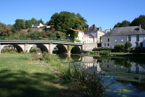
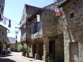
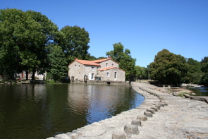
The Haut Bocage is a land of quiet rural landscapes with the occasional glimpse of a wider vista. There are small fields separated by narrow winding roads and lanes lined with tall hedges. There are many small coppices and quaint stone built villages with massive old churches that seem totally out of proportion to the size of the commune. Cutting through the Haut Bocage and forming the border with the neighbouring Departments of Deux Sèvres, Maine-Et-Loire and the Loire-Atlantique is the Sèvre-Nantaise, this river slowly meanders to join the mighty River Loire. The picturesque valley created by the Sèvre-Nantaise was once a centre of thriving local industry. All along its course it was used not only by harnessing the power of the water to drive watermills, but also by using the water itself in such industries as waving, leather, paper making, wool treatments and the grinding of flour. The legacy is a landscape of weirs, watermills, merchants’ houses and ancient factories. Throughout its length the river course is strewn with rounded boulders making it a paradise for artists and photographers alike.
The history of man’s occupation of the Haut Bocage dates from the Neolithic period. There is evidence of the Roman occupation, but it is not until the early medieval period that the region as we know it today starts to take shape. The advent of Catholicism began a period of building churches, priories and fortified castles. It was a time of feudalism with the region being governed by the great Dukes and Barons. The region was devastated by the 100 years War (against the English) and the Wars of Religion (Catholic against Protestant), but it was the uprising of 1793 known as the Wars of the Vendee, which proved to be critical in the history of the region. 800 parishes of the Bas-Poitou, as the region was called before the revolution of 1789, rose up against the Revolutionary Government and the ensuing civil war saw atrocities committed by both sides with tremendous loss of life. In quelling the counter revolutionaries of the Vendée, the revolutionary government virtually wiped out the local population and it took many generations before life returned to some degree of normality.
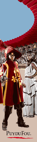
The Renaissance Chateau of the Puy du Fou was burnt by the "Colonne Infernale" of General Turreau in 1794. Today it is the site of the Vendée's world famous spectaculars, le Grand Parc and the Cinéscénie of the Puy du Fou, it is historic pageantry at its very best.
The Haut Bocage has some of the finest walks and cycle tracks in the Vendée, all are well signposted and maintained taking you through picturesque landscapes, there are locations for canoeing and other water sports. For those less mobile taking a quiet drive through the pretty lanes one will discover countless treasures with many peaceful cafes and restaurants to refresh the inner-self.
The Haut Bocage is a land of quiet rural landscapes with the occasional glimpse of a wider vista. There are small fields separated by narrow winding roads and lanes lined with tall hedges. There are many small coppices and quaint stone built villages with massive old churches that seem totally out of proportion to the size of the commune. Cutting through the Haut Bocage and forming the border with the neighbouring Departments of Deux Sèvres, Maine-Et-Loire and the Loire-Atlantique is the Sèvre-Nantaise, this river slowly meanders to join the mighty River Loire. The picturesque valley created by the Sèvre-Nantaise was once a centre of thriving local industry. All along its course it was used not only by harnessing the power of the water to drive watermills, but also by using the water itself in such industries as waving, leather, paper making, wool treatments and the grinding of flour. The legacy is a landscape of weirs, watermills, merchants’ houses and ancient factories. Throughout its length the river course is strewn with rounded boulders making it a paradise for artists and photographers alike.
The history of man’s occupation of the Haut Bocage dates from the Neolithic period. There is evidence of the Roman occupation, but it is not until the early medieval period that the region as we know it today starts to take shape. The advent of Catholicism began a period of building churches, priories and fortified castles. It was a time of feudalism with the region being governed by the great Dukes and Barons. The region was devastated by the 100 years War (against the English) and the Wars of Religion (Catholic against Protestant), but it was the uprising of 1793 known as the Wars of the Vendee, which proved to be critical in the history of the region. 800 parishes of the Bas-Poitou, as the region was called before the revolution of 1789, rose up against the Revolutionary Government and the ensuing civil war saw atrocities committed by both sides with tremendous loss of life. In quelling the counter revolutionaries of the Vendée, the revolutionary government virtually wiped out the local population and it took many generations before life returned to some degree of normality.
The Renaissance Chateau of the Puy du Fou was burnt by the "Colonne Infernale" of General Turreau in 1794. Today it is the site of the Vendée's world famous spectaculars, le Grand Parc and the Cinéscénie of the Puy du Fou, it is historic pageantry at its very best.
The Haut Bocage has some of the finest walks and cycle tracks in the Vendée, all are well signposted and maintained taking you through picturesque landscapes, there are locations for canoeing and other water sports. For those less mobile taking a quiet drive through the pretty lanes one will discover countless treasures with many peaceful cafes and restaurants to refresh the inner-self.
Towns & Villages in the Haut Bocage
Pouzauges
Reaumur
La Boupere
Saint Michel-Mont-Mercure
Mallievre
Les Epesses
Les Herbiers
Saint Laurent-sur-Sevre
Mortagne-sur-sevre
La Pommeraie-sur-Sevre
Cugand
Tiffauges
La Bruffiere
La Gaubretiere
La Chataigneraie
Cheffois
St.Mesmin
Reaumur
La Boupere
Saint Michel-Mont-Mercure
Mallievre
Les Epesses
Les Herbiers
Saint Laurent-sur-Sevre
Mortagne-sur-sevre
La Pommeraie-sur-Sevre
Cugand
Tiffauges
La Bruffiere
La Gaubretiere
La Chataigneraie
Cheffois
St.Mesmin