
Tourist Information, Vendee History, Accommodation, Photos, Reviews, Maps,

Custom Search
Web |


|
| contact us | ||
| Advertise |
|
| month by month guide | ||
| Entertainment |
| January | ||
| February | ||
| March | ||
| April | ||
| May | ||
| June | ||
| July | ||
| August | ||
| September | ||
| October | ||
| November | ||
| December |
| Car Boot Sale | ||
| Discos |
|
| Getting About | ||
| Public Holidays, | ||
| Getting to the Vendee | ||
| Bike Hire | ||
| Photos | ||
| Weather | ||
| Vendee Wars | ||
| Videos | ||
| Maps & Books | ||
| Vendee Wines | ||
| Vendee Information |
|
| Vendee Restaurants | ||
| Coastal Region | ||
| Haut Bocage | ||
| Bas Bocage | ||
| Plaine | ||
| Sud Vendee | ||
| Marais Poitevin | ||
| Marais Breton | ||
| Marais Olonne |
|
| All Activities | ||
| fishing | ||
| sailing | ||
| golf | ||
| Walking | ||
| Cycling | ||
| Surfing | ||
| Karting | ||
| Swimming | ||
| Canoeing | ||
| Paintball | ||
| Horse Riding | ||
| Adventure Parks | ||
| Arts & Crafts |
|
| All Attractions | ||
| Theme Parks | ||
| Towns and Villages | ||
| Chateaux and Churches | ||
| beaches of the vendee | ||
| Adventure Parks | ||
| Amusement Parks | ||
| Water Parks | ||
| Childrens Attractions | ||
| Markets | ||
| Zoos & Gardens | ||
| Museums | ||
| Rivers of the Vendee | ||
| Vendee Islands | ||
| Vendee Wars Sites | ||
| Mills of the Vendee |
| inland beaches |
|
| Gites | ||
| Hotels | ||
| Camping | ||
| Bed & Breakfast |
| Gites with Pools | ||
| Gites Complex | ||
| All Gites |
| Camping Coastal Region | ||
| Camping Haut Bocage | ||
| Camping Marais Poitevin | ||
| Camping Sud Vendee |
|
| Coastal Region | ||
| Bas Bocage | ||
| Haut Bocage | ||
| Plaine | ||
| Sud Vendee | ||
| Marais Poitevin | ||
| Marais Breton | ||
| Marais Olonne | ||
| Mervent Forest |


In
accordance with the law "and Freedoms" of January 6, 1978, you have the
right to access and rectify information concerning you. If you wish to
exercise this right, please contact us.
© Copyright Vendee-Guide.co.uk 2009-12 This Website is built with Bluevoda from Vodahost
© Copyright Vendee-Guide.co.uk 2009-12 This Website is built with Bluevoda from Vodahost
Marais Poitevin Photos
Marais Poitevin Attractions
Marais Poitevin Restaurants
Marais Poitevin Activities
Marais Poitevin Gites
Reviews of Marais Poitevin
Boat Hire Marais Poitevin.
Marais Poitevin Campsites
Marais Poitevin Attractions
Marais Poitevin Restaurants
Marais Poitevin Activities
Marais Poitevin Gites
Reviews of Marais Poitevin
Boat Hire Marais Poitevin.
Marais Poitevin Campsites
Marais Poitevin
The
Marais Poitevin is the largest of the three areas of Marais (marshlands)
in the Vendée. The Marais are what is left of the ancient Gulf of
Pictons a large basin that was scoured out during the last ice age and
which has since slowly been silted up by alluvial deposits left by the
local rivers and the Loire. During the Roman period at least 10
rivers drained into the gulf, but today just the Sèvre Niortaise, the Cure and the Lay
have Atlantic estuaries. During the early medieval period drainage of
the Marais was started by the Benedictine monks, the Dutch were brought
in later to continue the drainage work and built the Drogues (dykes) to
keep the sea at bay. Monks from the Abbey at Maillezais, which was built in 1005 on the site of a ruined chapel, together with monks from the Abbeys of St. Michel-en-Herm, Nieul-sur-l'Autise,
l'Absie and St. Maixant were responsible for all of the early drainage
work. The Monks had great skill as is evident by the construction of the
aqueduct at Maille, which was built between 1654 and 1662 following the completion of drainage work on the marshes around Vix.
Three Departments, The Vendée, Deux Sèvres and Charente-Maritime have areas of the Marais Poitevin within their borders, which is the second largest wetland in France covering approximately 0.5% of the total land mass of France.
The marshland can be divided into two parts, the Marais Mouille (wet marshes known locally as the Venise Vert or Green Venice and the Marais Dessèche (Dry marshes), between them they have over 24,000km of canals and ditches with a further 600kms of wider canals and rivers.
Today the ’Anse de LAiguillon is now more often referred to as le Baie-de-l'Aiguillon, although it once merited the designation of gulf. The bay consists of 5,000 hectares of mudflats, it is a stopping off point for migratory birds and has been designated a National Nature Reserve.
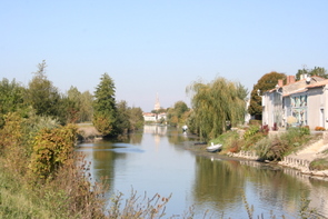
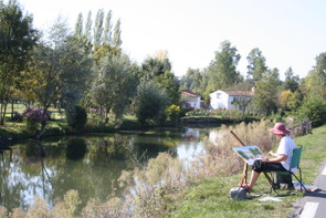
There are three distinct regions within the Marais Poitevin. The upper reaches of the Sèvre Niortaise and Vendée rivers, more commonly referred to as the Venise Vert or Green Venice, supports a thriving farming community. The small fields between tree lined canals makes this part of the Marais an extremely attractive area and therefore a popular tourist destination. Some farmers still transport their cattle from field to field in flat bottomed working barges; this traditional method of cattle husbandry is however a dying tradition and one is now lucky to see it in operation.
The Middle section is the largest area of the Marais, it is mainly devoid of trees the topography being principally determined by agriculture, these flat lands called Poulders are extremely fertile and productive. Within this area however there are several nature reserves and areas of common land, which belong to the communes and can be freely grazed. These common areas measure between 100 hectares and 300 hectares totalling some 2,000 hectares of grazing land.
The final section of the Marais is the land beyond the drainage control zone, this consists of salt marshes and mudflats all of which are washed at high tide by the sea but are however gradually silting up.
The Marais Poitevin is one of the richest natural habitats in France, attracting naturalists from all over the world. Over 250 species of birds of which 130 nest in the marshes, 44 species of mammals, 23 species of amphibians and reptiles, 322 species of fish and over 700 species of wild flora have been recorded
The following lists some of the more interesting sites and features that make up the workings of the Marais Poitevin.
Three Departments, The Vendée, Deux Sèvres and Charente-Maritime have areas of the Marais Poitevin within their borders, which is the second largest wetland in France covering approximately 0.5% of the total land mass of France.
The marshland can be divided into two parts, the Marais Mouille (wet marshes known locally as the Venise Vert or Green Venice and the Marais Dessèche (Dry marshes), between them they have over 24,000km of canals and ditches with a further 600kms of wider canals and rivers.
Today the ’Anse de LAiguillon is now more often referred to as le Baie-de-l'Aiguillon, although it once merited the designation of gulf. The bay consists of 5,000 hectares of mudflats, it is a stopping off point for migratory birds and has been designated a National Nature Reserve.
There are three distinct regions within the Marais Poitevin. The upper reaches of the Sèvre Niortaise and Vendée rivers, more commonly referred to as the Venise Vert or Green Venice, supports a thriving farming community. The small fields between tree lined canals makes this part of the Marais an extremely attractive area and therefore a popular tourist destination. Some farmers still transport their cattle from field to field in flat bottomed working barges; this traditional method of cattle husbandry is however a dying tradition and one is now lucky to see it in operation.
The Middle section is the largest area of the Marais, it is mainly devoid of trees the topography being principally determined by agriculture, these flat lands called Poulders are extremely fertile and productive. Within this area however there are several nature reserves and areas of common land, which belong to the communes and can be freely grazed. These common areas measure between 100 hectares and 300 hectares totalling some 2,000 hectares of grazing land.
The final section of the Marais is the land beyond the drainage control zone, this consists of salt marshes and mudflats all of which are washed at high tide by the sea but are however gradually silting up.
The Marais Poitevin is one of the richest natural habitats in France, attracting naturalists from all over the world. Over 250 species of birds of which 130 nest in the marshes, 44 species of mammals, 23 species of amphibians and reptiles, 322 species of fish and over 700 species of wild flora have been recorded
The following lists some of the more interesting sites and features that make up the workings of the Marais Poitevin.
| • | The Green Venice |
| • | Le Port de Courdault |
| • | The Aquaduct of Maille |
| • | The Hydaulic Node at Bazoin |
| • | The Barrage at Boisse |
| • | The Canal Ceinture des Hollandais |
| • | Les Portes a la Mer (tide gates) |
| • | The commons |
| • | Le Bateau a Chaine |
| • | Les anciens Marais Salants |
| • | L'ancient port de Lucon |
| • | L'Ile de la Dive |
| • | Les Polders autour de Triaize |
| • | L'Ecuse de la Pionte aux Herbes |
| • | Le Pont du Brault |
| • | La Pointe de L'Aiguillon Les Mizottes (salt Marshes) Le Baie de l'Aiguillon |
Towns & Villages in the Marais Poitevin
Maillezais
Maille
Coulon
Damvix
Arcais
Port de Courdault
Triaize
Saint Michel-en-l'Herm
Lucon
Chaille-les-Marais
Saint denis du Payre
Nieul-sur-l'Autise
Maille
Coulon
Damvix
Arcais
Port de Courdault
Triaize
Saint Michel-en-l'Herm
Lucon
Chaille-les-Marais
Saint denis du Payre
Nieul-sur-l'Autise
Bike Hire on the Marais Poitevin;
Damvix.Equestrian Centre, 2,La Maison des Champs. Tel. 06 80 45 69 98.
Maillezais: Embarcadere de l'Abbaye. Le Grand Port. Tel. 02 51 87 21 87
Le Mazeau: Le Port. Tel. 02 51 52 90 73.
Restaurants; The Marais Poitevin has a whole host of restaurants, many specialising in the local cuisine.
For more details see Marais Poitevin Restaurants
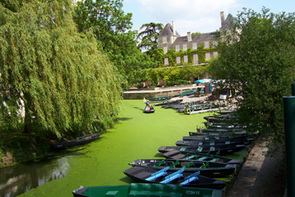
Boat Hire; Throughout the Marais poitevin you will find a large number of places where you can hire a boat to take a close up look at this most attractive region. For a full details see Boat hire Marais poitevin
Damvix.Equestrian Centre, 2,La Maison des Champs. Tel. 06 80 45 69 98.
Maillezais: Embarcadere de l'Abbaye. Le Grand Port. Tel. 02 51 87 21 87
Le Mazeau: Le Port. Tel. 02 51 52 90 73.
Restaurants; The Marais Poitevin has a whole host of restaurants, many specialising in the local cuisine.
For more details see Marais Poitevin Restaurants
Boat Hire; Throughout the Marais poitevin you will find a large number of places where you can hire a boat to take a close up look at this most attractive region. For a full details see Boat hire Marais poitevin